Development of a Geospatial Web-based Tool to Assess Trade-Offs of Sampling Plans for Characterizing Contaminant Releases
Project Brief
The Challenge
Conducting sampling to characterize a large-scale contaminant release over a wide area can require significant time and resources. The U.S. Environmental Protection Agency wanted to be able to (1) assess the feasibility and cost-benefit trade-offs of sampling designs before selecting and implementing a sampling plan, and (2) operationalize sampling plans for the field within a geospatial context. EPA selected ERG to develop a geospatial web-based tool to achieve these goals.
ERG's Solution
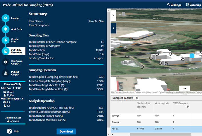
ERG’s multidisciplinary project team began this work by researching and developing a science-based model to estimate the resource demands of sampling plans. We then transformed that model into a web-based GIS application, the Trade-Off Tool for Sampling (TOTS), that allows users to easily design and then analyze a variety of sample plans. ERG’s team used agile methods to develop TOTS in increments that included prototype development, tabletop exercises to solicit user feedback, and subsequent refinement of user-focused functionality to create an intuitive application. EPA and other partners can use TOTS to quickly analyze cost-benefit trade-offs in sampling designs and then export plans to ArcGIS Online and rapidly operationalize them to support field data collection activities.
TOTS is a custom GIS-based web application to create sampling designs and estimate associated resource demands (i.e., cost and time) for biological contamination characterization. Users can plot samples in a 3D map to characterize an area. Results inform the selection of an appropriate sampling technique based on an evaluation of sampling and data quality objectives. Tool output further supports executing the sampling plan and capturing related data while in the field.
Client
U.S. Environmental Protection Agency